A powerful winter storm is taking aim at the Midwest, prompting urgent blizzard warnings for three states this Sunday. Michigan, Nebraska, and South Dakota are all in the crosshairs of a system expected to bring extreme snowfall, fierce winds, and potentially life-threatening travel conditions.
States Under the Gun
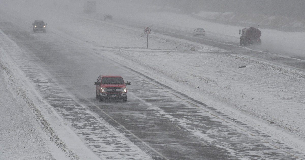
The National Weather Service has issued its most severe winter weather alert for parts of Michigan, Nebraska, and South Dakota. The situation is most dire in Michigan's Upper Peninsula, where forecasters predict a staggering 18 to 34 inches of snow. Combined with wind gusts up to 45 miles per hour, this will create massive drifts and near-zero visibility.

While snowfall totals will be lower in Nebraska and South Dakota, the danger there comes from the wind. Gusts could roar up to 70 miles per hour, creating ground blizzard conditions where existing snow is whipped into blinding, whiteout walls. "Travel will become very difficult to impossible due to whiteout conditions," the warning states, adding that the fierce winds may damage trees and cause power outages.
Official Warning: Stay Home
Authorities are delivering a blunt and unified message to residents: do not travel. The official alert leaves no room for interpretation, stating, "Travel should be restricted to emergencies only." It emphasizes that a Blizzard Warning means severe winter conditions are expected, with falling and blowing snow leading to extreme danger for anyone on the roads.
"If you must travel, have a winter survival kit with you. If you get stranded, stay with your vehicle," the warning continues. The directive is clear—staying put is the safest course of action. This kind of severe weather can strand motorists in minutes, turning a short trip into a dangerous crisis. For more on how major storms can disrupt regional plans, see our report on Travel Plans Frozen: Major Snowstorm Threatens Weekend Sports, Travel Across Midwest.
Impact on Local Communities and Events
The timing of this storm on a Sunday will likely cause significant disruption. The warnings for Michigan are in effect until Tuesday morning, indicating a long-duration event. Counties like Central Chippewa, Eastern Mackinac, Western Chippewa, and Western Mackinac are expected to bear the brunt of the heavy snow. This follows a pattern of intense winter weather affecting weekend activities across the country, similar to the Winter Storm Chaos we reported earlier this season.
Residents are urged to prepare now. This means ensuring you have essential supplies at home, checking on neighbors, and securing any outdoor items that could become projectiles in the high winds. The combination of heavy snow and hurricane-force gusts creates a unique and severe hazard.
Essential Winter Driving Tips If You MUST Go
While the strong advice is to avoid travel entirely, if an emergency forces you onto the roads, extreme caution is required. Here are critical safety tips to remember:
- Slow Down: Speed is your enemy on snow and ice. Adjust your speed for drastically lower traction.
- Increase Following Distance: Allow five to six seconds of space between you and the car ahead for safe stopping.
- Know Your Brakes: Apply steady, firm pressure. If you have anti-lock brakes, understand how they feel when engaged.
- Avoid Stopping on Hills: Try to maintain momentum going up a hill and proceed down hills very slowly.
- Don't Power Up Hills: Applying extra gas will only spin your wheels. Use inertia from a flat approach.
Remember, the safest decision is to postpone any travel until conditions improve. This storm is not just an inconvenience; it's a serious threat to safety.
A Broader Pattern of Severe Weather
This blizzard threat is part of an active pattern of severe weather impacting the nation. Just as this storm targets the Midwest with snow, other regions frequently face different dangers. For instance, Severe Weather Alert: Seven States Face Tornado Threat This Sunday highlights how spring and fall can bring volatile storms to the South and Plains. Staying informed about all types of severe weather is crucial for safety year-round.
As the storm develops, keep a close eye on official forecasts and warnings from your local National Weather Service office. Have multiple ways to receive alerts in case of power outages. Communities in the warned areas should band together, check on vulnerable neighbors, and heed all official guidance. This is a time for caution and preparedness, not for taking risks on treacherous roads.